IB Geography Internal Assessment Criteria: A Comprehensive Guide
The IB Geography Internal Assessment (IA) is a crucial component of your final grade. Understanding the geography internal assessment criteria is key to achieving a high score. This guide provides a detailed breakdown of each criterion, offering practical tips and examples to help you excel. We'll explore the IB geography grading rubric, ensuring you know exactly what examiners are looking for.
What is the Geography Internal Assessment?
The Geography Internal Assessment is a piece of independent fieldwork and analysis conducted by IB Geography students. It's an opportunity to apply geographical concepts and skills to a real-world issue, allowing you to demonstrate your understanding of the subject matter and your ability to conduct research. The IA is marked internally by your teacher and then externally moderated by the IB.
Struggling with IB Assessments?
Get instant, detailed feedback on your work with AI that understands IB criteria.
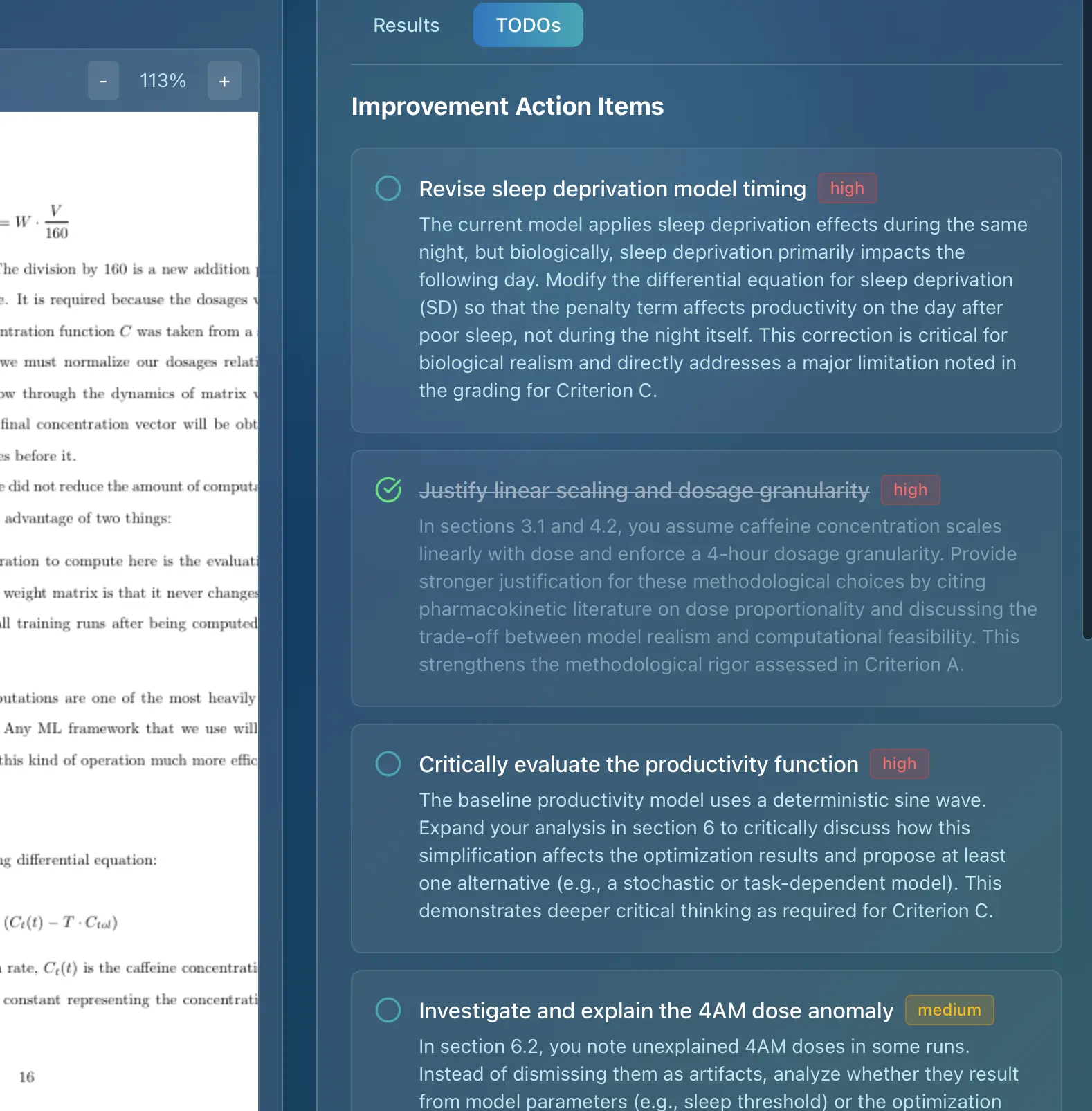
Understanding the Grading Criteria
The IB Geography IA is assessed against six criteria, each focusing on different aspects of the investigation. Each criterion is marked out of a specific number of points, and the total score contributes to your overall IB grade. Familiarizing yourself with these criteria is the first step towards a successful IA. Let's delve into each criterion in detail.
Detailed Breakdown of Geography Internal Assessment Criteria
Criterion A: Fieldwork Question and Geographic Context (3 marks)
What it assesses: This criterion assesses the focus and geographical nature of the fieldwork question, its link to the syllabus, and the presentation of the geographic context. In essence, it's about setting the stage for your investigation.
Mark bands:
- 0 Marks: The fieldwork question is absent, irrelevant, or lacks a clear geographical focus. The geographic context is not presented.
- 1 Mark: The fieldwork question is vaguely defined or weakly linked to the geography syllabus. The geographic context is poorly described or lacks essential information. Mapping conventions are not followed.
- 2 Marks: The fieldwork question is generally focused and linked to the geography syllabus. The geographic context is presented with some relevant background information and a map. Mapping conventions are mostly followed.
- 3 Marks: The fieldwork question is geographical and focused, clearly identifying a precise location allowing for primary data collection. The link between the fieldwork question and the relevant syllabus topic or geographical theory is described. One or more locational maps are presented and follow mapping conventions, providing clear information and details of the fieldwork location.
Tips for success:
- Choose a focused question: Avoid overly broad questions. Instead, narrow your focus to a specific issue in a particular location. For example, instead of "How does tourism affect the environment?", consider "How does cruise ship tourism impact water quality in the bay of X?".
- Link to the syllabus: Explicitly state which syllabus topic your question relates to. This demonstrates your understanding of the curriculum.
- Provide detailed geographic context: Include relevant background information about the location, such as its physical geography, population, economy, and environmental issues.
- Use maps effectively: Include clear and accurate maps showing the location of your fieldwork site, its surrounding area, and any relevant geographical features. Ensure mapping conventions are followed (north arrow, scale, key, title).
Criterion B: Methods of Investigation (3 marks)
What it assesses: This criterion assesses the description and justification of the methods used for data collection. It's about demonstrating that you chose appropriate methods and can explain why.
Mark bands:
- 0 Marks: The methods of investigation are not described or are entirely inappropriate.
- 1 Mark: The methods of investigation are described superficially, lacking detail and justification. The link to the fieldwork question is unclear.
- 2 Marks: The methods of investigation are described with some detail, including technologies employed, sampling techniques, and circumstances of the fieldwork. Justification is attempted but may be weak.
- 3 Marks: The method(s) used for information and data collection are described, explaining clearly and accurately how the combination of data collected is relevant to the theory, question formulated or the hypotheses for the internal assessment. The method(s), data collection instruments/technologies and sampling/surveying techniques are used correctly, resulting in reliable and good quality primary data supporting a relevant quantitative and/or qualitative analysis.
Tips for success:
- Describe your methods in detail: Explain exactly how you collected your data, including the equipment used, the sampling techniques employed (e.g., random, stratified, systematic), and the number of data points collected.
- Justify your choices: Explain why you chose those particular methods. How are they appropriate for answering your research question? What are their strengths and limitations?
- Link to the fieldwork question: Clearly explain how your methods will help you answer your research question.
- Consider both quantitative and qualitative data: A mix of both often provides a more comprehensive understanding.
Criterion C: Quality and Treatment of Information Collected (6 marks)
What it assesses: This criterion assesses the relevance, quantity, and quality of the data collected, as well as the appropriateness and effectiveness of the techniques used to present the data.
Mark bands:
- 0 Marks: The data collected is irrelevant, insufficient, or of poor quality. Data presentation is absent or inappropriate.
- 1-2 Marks: The data collected is partially relevant and of limited quantity or quality. Data presentation is attempted, but techniques are poorly chosen or executed. Conventions are not followed.
- 3-4 Marks: The data collected is mostly relevant and of reasonable quantity and quality. Data presentation techniques are generally appropriate, but there may be some weaknesses in execution or adherence to conventions.
- 5-6 Marks: The information and data collected is all directly relevant to the question formulated or the hypotheses, and is sufficient in quantity and quality to allow for analysis or answering of the question formulated. The most appropriate techniques have been used effectively for the presentation of information and data collected. The graphs, tables, diagrams or other illustrations follow conventions (labelling, titles, and so on).
Tips for success:
- Collect relevant data: Ensure that all the data you collect directly relates to your research question.
- Collect sufficient data: Gather enough data to allow for meaningful analysis. The amount of data needed will depend on your research question and methods.
- Ensure data quality: Take steps to ensure the accuracy and reliability of your data. This might involve using calibrated equipment, following standardized procedures, and taking multiple measurements.
- Present data effectively: Choose appropriate data presentation techniques, such as graphs, tables, maps, and diagrams. Ensure that all presentations are clear, accurate, and follow conventions (e.g., labeled axes, titles, keys).
Criterion D: Written Analysis (8 marks)
What it assesses: This criterion assesses the quality of the analysis of the results, including the interpretation of trends, patterns, and anomalies, and the links to the fieldwork question, hypotheses, geographic context, and methods used.
Mark bands:
- 0 Marks: The analysis is absent or completely irrelevant.
- 1-2 Marks: The analysis is superficial and lacks depth. There is little or no interpretation of results, and the links to the fieldwork question and geographic context are weak.
- 3-4 Marks: The analysis demonstrates some understanding of the results, but the interpretation is limited. Links to the fieldwork question, hypotheses, and geographic context are present but may be incomplete.
- 5-6 Marks: The analysis includes descriptive and statistical techniques that are appropriate to the data and the question formulated. The trends, patterns and statistics found, including outliers and anomalies if present, are explained and linked to the question formulated, hypotheses, geographical theory, the fieldwork location and methods used. There may be some minor gaps in the supporting evidence.
- 7-8 Marks: The written analysis includes descriptive and statistical techniques (with confidence levels if appropriate) that are appropriate to the data and the question formulated. The trends, patterns and statistics found, including outliers and anomalies if present, are explained and linked to the question formulated, hypotheses, geographical theory, the fieldwork location and methods used. The written analysis allows for answering the question formulated, with no or only minor gaps in the supporting evidence.
Tips for success:
- Go beyond description: Don't just describe your data; analyze it. Look for trends, patterns, and anomalies.
- Use statistical techniques: Employ appropriate statistical techniques to analyze your data, such as measures of central tendency (mean, median, mode), measures of dispersion (range, standard deviation), and correlation analysis.
- Interpret your results: Explain what your results mean in relation to your research question, hypotheses, and geographic context.
- Link to geographical theory: Connect your findings to relevant geographical theories and concepts.
- Address anomalies: Explain any unexpected or unusual results.
- Use supporting evidence: Back up your analysis with evidence from your data.
Criterion E: Conclusion (2 marks)
What it assesses: This criterion assesses the clarity and justification of the conclusion in relation to the research question and the analysis conducted.
Mark bands:
- 0 Marks: The conclusion is absent, unclear, or unrelated to the research question and analysis.
- 1 Mark: The conclusion is present but lacks clarity or is weakly supported by the analysis.
- 2 Marks: There is a clear conclusion to the fieldwork question, which is supported by the analysis.
Tips for success:
- Clearly answer your research question: State your conclusion in a clear and concise manner.
- Support your conclusion with evidence: Summarize the key findings from your analysis that support your conclusion.
- Avoid introducing new information: The conclusion should be based on the analysis presented in the previous section.
Criterion F: Evaluation (3 marks)
What it assesses: This criterion assesses the evaluation of the methodology and approach to the fieldwork, including the identification of strengths and weaknesses, and suggestions for improvement.
Mark bands:
- 0 Marks: The evaluation is absent or superficial.
- 1 Mark: The evaluation identifies some strengths and weaknesses of the methodology, but the discussion is limited. Suggestions for improvement are vague or unrealistic.
- 2 Marks: The most appropriate and relevant strengths and/or weaknesses are explained regarding the data collection methods, the formulation of the fieldwork research question, the presentation of data/information and the choice of location. Suggestions for improvement are outlined.
- 3 Marks: The most appropriate and relevant strengths and/or weaknesses are explained regarding the data collection methods, the formulation of the fieldwork research question, the presentation of data/information and the choice of location. Suggestions for improvement are outlined and the potential impact of these improvements is explained.
Tips for success:
- Identify strengths and weaknesses: Discuss the strengths and weaknesses of your fieldwork methods, data collection techniques, and analysis.
- Be specific: Provide concrete examples to support your evaluation.
- Suggest realistic improvements: Propose specific and realistic ways to improve your fieldwork in the future.
- Explain the impact of improvements: Explain how these improvements would address the weaknesses you identified and potentially lead to more accurate or reliable results.
How to Excel in Your Geography Internal Assessment
- Start early: Don't leave the IA until the last minute. Give yourself plenty of time to plan, conduct fieldwork, analyze data, and write your report.
- Choose a topic you are interested in: This will make the process more enjoyable and engaging.
- Seek guidance from your teacher: Your teacher is your best resource for advice and support.
- Plan your fieldwork carefully: Develop a detailed fieldwork plan before you start collecting data.
- Keep accurate records: Maintain detailed records of your fieldwork methods, data collection, and analysis.
- Proofread your work carefully: Check for errors in grammar, spelling, and punctuation.
Pro Tip: Get AI-Powered Grading
Stop second-guessing your grades. Get instant feedback aligned with official IB rubrics.
Common Mistakes to Avoid
- Choosing a question that is too broad or too narrow.
- Failing to link the fieldwork question to the syllabus.
- Using inappropriate or poorly justified methods.
- Collecting insufficient or irrelevant data.
- Failing to analyze the data effectively.
- Drawing conclusions that are not supported by the data.
- Failing to evaluate the methodology.
- Plagiarism.
The Role of AI in Modern Assessment
Modern technology is revolutionizing how we approach academic assessment. AI-powered grading assistants can now help teachers maintain consistency and accuracy in their evaluations while saving valuable time. These tools use the same official IB criteria to provide detailed feedback and scoring, ensuring that assessments meet the high standards expected in IB programs.
For educators looking to streamline their grading process while maintaining the quality and consistency that IB assessments demand, AI grading assistance offers a powerful solution that complements traditional teaching methods.
Conclusion
Understanding the IB Geography Internal Assessment criteria is essential for success. By following the tips and advice in this guide, you can increase your chances of achieving a high score. Remember to plan carefully, conduct thorough fieldwork, analyze your data effectively, and write a clear and concise report. Good luck!
Looking for more support with IB assessment grading? Discover how AI-powered grading assistants can help maintain consistency and accuracy in your evaluations while saving valuable time. Learn more about modern grading solutions designed specifically for IB educators.