How to Write a High-Quality IB Geography IA Report
Are you an IB Geography student aiming for a top score on your Internal Assessment (IA)? Writing a high-quality IB Geography IA report can seem daunting, but with the right guidance, you can achieve excellent results. This comprehensive guide will walk you through each stage of the IA process, from choosing a fieldwork question to writing a compelling conclusion. We'll provide practical tips, examples, and strategies to help you meet the IB's rigorous assessment criteria and maximize your marks. Whether you're just starting or looking to refine your existing work, this guide will equip you with the knowledge and tools you need to succeed.
Introduction: Mastering Your IB Geography IA
The IB Geography Internal Assessment (IA) is a crucial component of your final grade, representing 25% of your overall mark. It's your opportunity to showcase your understanding of geographical concepts, research skills, and analytical abilities through an independent fieldwork investigation. A well-executed IA demonstrates your ability to apply theoretical knowledge to real-world situations, collect and analyze data, and draw meaningful conclusions. This guide provides a step-by-step approach to crafting a high-quality IA report that meets the IB's demanding standards. We'll cover everything from formulating a strong research question) to presenting your findings effectively.
Struggling with IB Assessments?
Get instant, detailed feedback on your work with AI that understands IB criteria.
Core Content Sections
1. Choosing a Compelling Fieldwork Question (Criterion A)
The foundation of a successful IA is a well-defined and geographically relevant fieldwork question. This question should be focused, researchable, and linked to the IB Geography syllabus.
-
What Makes a Good Fieldwork Question?
- Specificity: Avoid broad questions. Instead of "How does tourism affect a city?", try "How does the presence of Airbnb rentals impact residential property values in the Kensington Market neighborhood of Toronto?".
- Geographical Focus: The question should clearly relate to geographical concepts such as location, spatial distribution, human-environment interaction, or regional analysis.
- Data Availability: Ensure you can collect sufficient primary data to answer your question. Consider accessibility, time constraints, and ethical considerations.
- Syllabus Link: Explicitly connect your question to a specific topic or concept within the IB Geography syllabus. For example, your question might relate to urban environments, climate change, resource management, or population dynamics.
-
Presenting the Geographic Context:
- Provide a detailed description of your study area, including its location, physical characteristics, socio-economic conditions, and relevant geographical features.
- Include maps that clearly show the location of your study area and any relevant features (e.g., land use, transportation networks, environmental hazards). Ensure your maps follow mapping conventions (title, legend, scale, north arrow).
- Example: If your question focuses on coastal erosion, describe the geology, wave climate, and coastal management strategies in your study area.
-
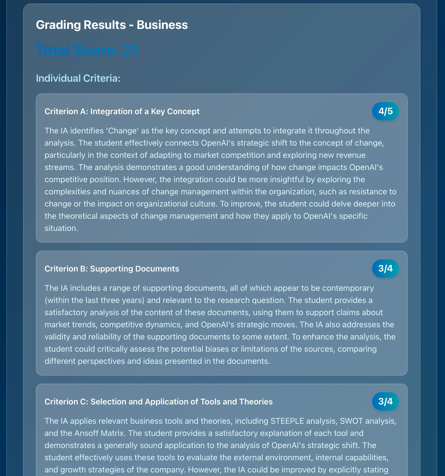
Meeting Criterion A Requirements:
- 0 Marks: The fieldwork question is absent, irrelevant, or lacks a clear geographical focus. The geographic context is not presented.
- 1 Mark: The fieldwork question is vaguely defined or weakly linked to the geography syllabus. The geographic context is poorly described or lacks essential information. Mapping conventions are not followed.
- 2 Marks: The fieldwork question is generally focused and linked to the geography syllabus. The geographic context is presented with some relevant background information and a map. Mapping conventions are mostly followed.
- 3 Marks: The fieldwork question is geographical and focused, clearly identifying a precise location allowing for primary data collection. The link between the fieldwork question and the relevant syllabus topic or geographical theory is described. One or more locational maps are presented and follow mapping conventions, providing clear information and details of the fieldwork location.
2. Designing Effective Methods of Investigation (Criterion B)
Your methods of investigation should be carefully planned and justified to ensure you collect reliable and relevant data.
-
Describing Your Methods:
- Clearly explain the specific methods you used to collect data (e.g., surveys, interviews, observations, environmental measurements).
- Provide details about your sampling techniques (e.g., random sampling, stratified sampling, systematic sampling) and justify your choices.
- Describe any technologies or equipment you used (e.g., GPS devices, weather stations, water quality testing kits).
-
Justifying Your Methods:
- Explain why you chose each method and how it is appropriate for answering your fieldwork question.
- Discuss the strengths and limitations of each method.
- Explain how your methods will allow you to collect data that is relevant, accurate, and reliable.
-
Example: If you are investigating the impact of traffic pollution on air quality, you might use air quality monitoring devices at different locations and conduct traffic counts to correlate traffic volume with pollution levels. Justify why these methods are appropriate for measuring air quality and traffic volume, and discuss any potential sources of error.
-
Meeting Criterion B Requirements:
- 0 Marks: The methods of investigation are not described or are entirely inappropriate.
- 1 Mark: The methods of investigation are described superficially, lacking detail and justification. The link to the fieldwork question is unclear.
- 2 Marks: The methods of investigation are described with some detail, including technologies employed, sampling techniques, and circumstances of the fieldwork. Justification is attempted but may be weak.
- 3 Marks: The method(s) used for information and data collection are described, explaining clearly and accurately how the combination of data collected is relevant to the theory, question formulated or the hypotheses for the internal assessment. The method(s), data collection instruments/technologies and sampling/surveying techniques are used correctly, resulting in reliable and good quality primary data supporting a relevant quantitative and/or qualitative analysis.
3. Ensuring Quality and Effective Treatment of Information Collected (Criterion C)
The quality and presentation of your data are crucial for demonstrating your understanding of the topic.
-
Data Relevance and Quality:
- Ensure that all data collected is directly relevant to your fieldwork question.
- Strive for accuracy and reliability in your data collection methods.
- Collect a sufficient quantity of data to allow for meaningful analysis.
-
Data Presentation Techniques:
- Use a variety of appropriate data presentation techniques, such as graphs, tables, maps, diagrams, and photographs.
- Choose techniques that effectively communicate your findings and highlight key trends and patterns.
- Follow conventions for labeling, titling, and formatting your data presentations.
-
Example: If you are investigating the relationship between slope angle and soil moisture, you might present your data in a scatter plot showing the correlation between these two variables. Ensure your graph has clear labels, a title, and a trendline (if appropriate).
-
Meeting Criterion C Requirements:
- 0 Marks: The data collected is irrelevant, insufficient, or of poor quality. Data presentation is absent or inappropriate.
- 1-2 Marks: The data collected is partially relevant and of limited quantity or quality. Data presentation is attempted, but techniques are poorly chosen or executed. Conventions are not followed.
- 3-4 Marks: The data collected is mostly relevant and of reasonable quantity and quality. Data presentation techniques are generally appropriate, but there may be some weaknesses in execution or adherence to conventions.
- 5-6 Marks: The information and data collected is all directly relevant to the question formulated or the hypotheses, and is sufficient in quantity and quality to allow for analysis or answering of the question formulated. The most appropriate techniques have been used effectively for the presentation of information and data collected. The graphs, tables, diagrams or other illustrations follow conventions (labelling, titles, and so on).
4. Conducting a Thorough Written Analysis (Criterion D)
The analysis section is where you demonstrate your understanding of the data and its implications.
-
Interpreting Trends and Patterns:
- Identify and describe any significant trends, patterns, or anomalies in your data.
- Use statistical techniques (e.g., mean, median, standard deviation, correlation) to support your analysis.
- Explain the underlying reasons for the observed trends and patterns, linking them to geographical concepts and theories.
-
Linking to the Fieldwork Question and Geographic Context:
- Clearly explain how your findings relate to your fieldwork question and the geographic context of your study area.
- Discuss any unexpected results or limitations of your data.
-
Example: If you are investigating the impact of urbanization on river water quality, you might analyze your data to determine if there is a correlation between urban land use and levels of pollutants in the river. Explain the possible sources of these pollutants and how they relate to urban activities.
-
Meeting Criterion D Requirements:
- 0 Marks: The analysis is absent or completely irrelevant.
- 1-2 Marks: The analysis is superficial and lacks depth. There is little or no interpretation of results, and the links to the fieldwork question and geographic context are weak.
- 3-4 Marks: The analysis demonstrates some understanding of the results, but the interpretation is limited. Links to the fieldwork question, hypotheses, and geographic context are present but may be incomplete.
- 5-6 Marks: The analysis includes descriptive and statistical techniques that are appropriate to the data and the question formulated. The trends, patterns and statistics found, including outliers and anomalies if present, are explained and linked to the question formulated, hypotheses, geographical theory, the fieldwork location and methods used. There may be some minor gaps in the supporting evidence.
- 7-8 Marks: The written analysis includes descriptive and statistical techniques (with confidence levels if appropriate) that are appropriate to the data and the question formulated. The trends, patterns and statistics found, including outliers and anomalies if present are explained and linked to the question formulated, hypotheses, geographical theory, the fieldwork location and methods used. The written analysis allows for answering the question formulated, with no or only minor gaps in the supporting evidence.
5. Crafting a Clear and Justified Conclusion (Criterion E)
Your conclusion should summarize your findings and answer your fieldwork question.
-
Summarizing Key Findings:
- Briefly restate your fieldwork question and the main findings of your analysis.
- Highlight the key trends and patterns that emerged from your data.
-
Answering the Fieldwork Question:
- Provide a clear and concise answer to your fieldwork question, based on the evidence presented in your analysis.
- Avoid introducing new information or arguments in your conclusion.
-
Example: If your fieldwork question was "How does the distance from a landfill site affect property values?", your conclusion should state whether your analysis supports the hypothesis that property values decrease with proximity to the landfill.
-
Meeting Criterion E Requirements:
- 0 Marks: The conclusion is absent, unclear, or unrelated to the research question and analysis.
- 1 Mark: The conclusion is present but lacks clarity or is weakly supported by the analysis.
- 2 Marks: There is a clear conclusion to the fieldwork question, which is supported by the analysis.
6. Evaluating Your Methodology and Approach (Criterion F)
The evaluation section is your opportunity to reflect on the strengths and weaknesses of your IA and suggest improvements.
-
Identifying Strengths and Weaknesses:
- Discuss the strengths and weaknesses of your data collection methods, data presentation techniques, and analytical approaches.
- Consider any limitations of your study, such as sample size, data accuracy, or external factors that may have influenced your results.
-
Suggesting Improvements:
- Propose specific and realistic improvements to your methodology and approach.
- Explain how these improvements could enhance the validity and reliability of your findings.
-
Example: You might acknowledge that your sample size was limited due to time constraints and suggest that future studies could benefit from a larger sample to improve the statistical significance of the results.
-
Meeting Criterion F Requirements:
- 0 Marks: The evaluation is absent or superficial.
- 1 Mark: The evaluation identifies some strengths and weaknesses of the methodology, but the discussion is limited. Suggestions for improvement are vague or unrealistic.
- 2 Marks: The most appropriate and relevant strengths and/or weaknesses are explained regarding the data collection methods, the formulation of the fieldwork research question, the presentation of data/information and the choice of location. Suggestions for improvement are outlined.
- 3 Marks: The most appropriate and relevant strengths and/or weaknesses are explained regarding the data collection methods, the formulation of the fieldwork research question, the presentation of data/information and the choice of location. Suggestions for improvement are outlined and the potential impact of these improvements is explained.
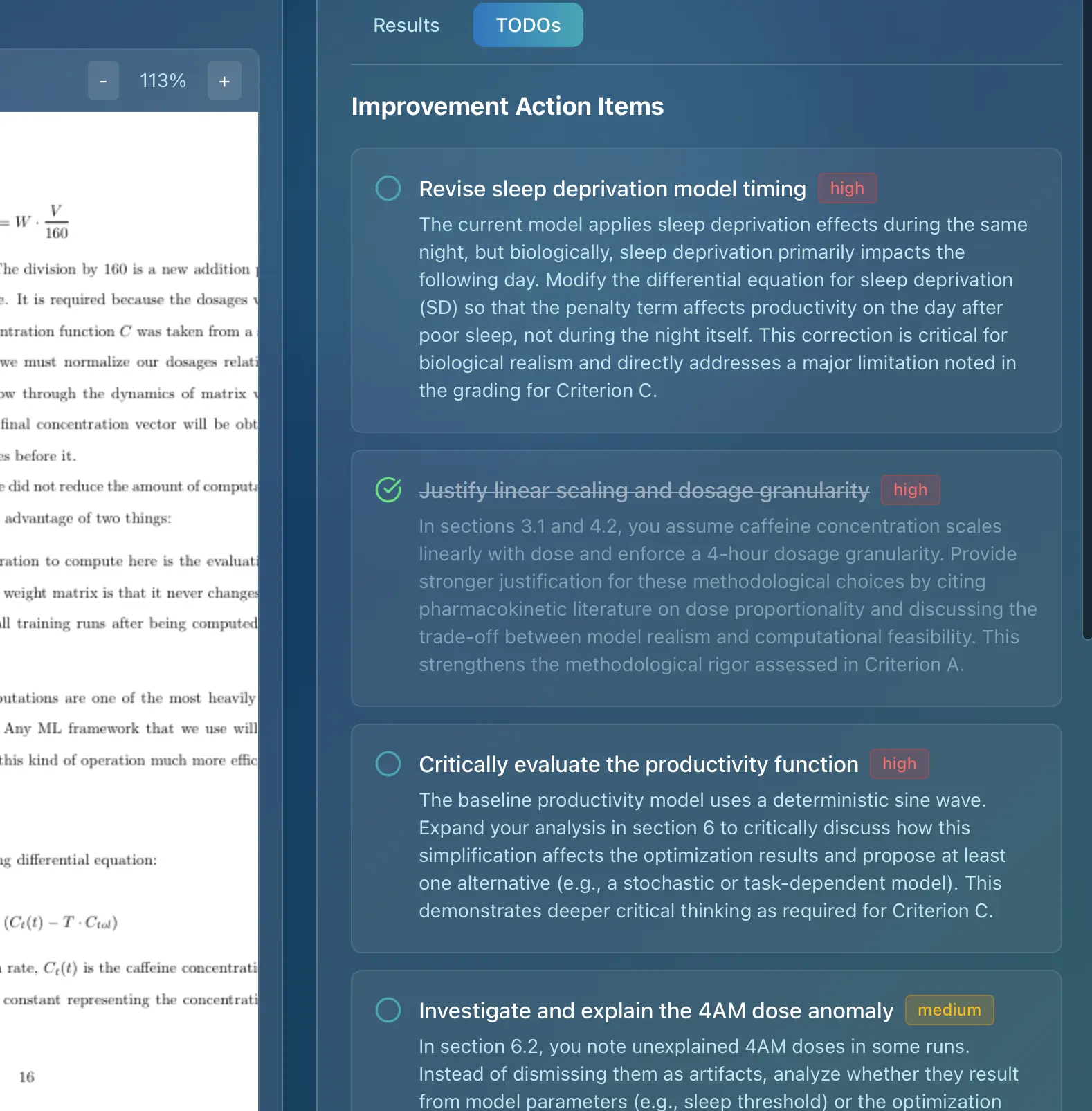
Common Challenges/Mistakes
- Poorly Defined Research Question: A vague or overly broad question makes it difficult to collect relevant data and draw meaningful conclusions.
- Solution: Refine your question to be specific, focused, and geographically relevant.
- Inadequate Data Collection: Insufficient or unreliable data can compromise the validity of your findings.
- Solution: Plan your data collection methods carefully, ensuring you collect enough data to support your analysis.
- Weak Analysis: A superficial or descriptive analysis fails to demonstrate a deep understanding of the data.
- Solution: Use appropriate statistical techniques to analyze your data and explain the underlying reasons for observed trends and patterns.
- Lack of Connection to Geographical Concepts: Failing to link your findings to relevant geographical concepts and theories weakens your IA.
- Solution: Explicitly connect your analysis to the IB Geography syllabus and relevant geographical literature.
- Poor Presentation: Unclear or poorly formatted data presentations can hinder understanding.
- Solution: Use appropriate data presentation techniques and follow conventions for labeling, titling, and formatting.
Advanced Tips/Strategies
- Consult Geographical Literature: Research existing studies on your topic to gain insights into appropriate methodologies and analytical approaches.
- Use GIS Software: Geographic Information Systems (GIS) software can be used to create maps, analyze spatial data, and visualize your findings.
- Seek Feedback: Ask your teacher or peers to review your IA and provide constructive criticism.
- Focus on Depth Over Breadth: It's better to conduct a thorough investigation of a narrow topic than a superficial investigation of a broad topic.
- Consider Ethical Implications: Ensure your research methods are ethical and respect the privacy and rights of individuals and communities.
Pro Tip: Get AI-Powered Grading
Stop second-guessing your grades. Get instant feedback aligned with official IB rubrics.
Technology and Modern Assessment
Technology is revolutionizing IB assessment, offering new tools and approaches to enhance learning and evaluation. AI-powered platforms are emerging as valuable resources for both students and teachers.
For example, Marksy is an AI grading assistant specifically designed for the International Baccalaureate. It provides instant, accurate, and detailed feedback on student work based on official IB rubrics. This helps students understand exactly how to improve their work and helps teachers save time by automating the grading process.
Marksy uses official IB criteria to ensure accuracy and fairness in assessment. The platform provides rubric-aligned scoring, detailed criterion-by-criterion feedback, and suggestions for improvement. This allows teachers to provide consistent and comprehensive feedback to students, helping them to achieve their full potential.
The use of AI in assessment also promotes transparency and objectivity. By relying on standardized rubrics and algorithms, AI tools can minimize bias and ensure that all students are assessed fairly. This can lead to more accurate and reliable assessments, as well as increased student confidence in the grading process.
Conclusion with Clear Next Steps
Writing a high-quality IB Geography IA report requires careful planning, diligent research, and a thorough understanding of the IB's assessment criteria. By following the tips and strategies outlined in this guide, you can increase your chances of achieving a top score. Remember to choose a compelling fieldwork question, design effective methods of investigation, present your data clearly, conduct a thorough analysis, and evaluate your methodology.
Next Steps:
- Review the IB Geography IA Guide: Familiarize yourself with the official IB guidelines for the Internal Assessment.
- Choose a Fieldwork Question: Select a topic that interests you and is relevant to the IB Geography syllabus.
- Plan Your Data Collection: Design your methods of investigation and ensure you have the resources to collect sufficient data.
- Start Writing: Begin drafting your IA report, following the structure and guidelines outlined in this guide.
- Seek Feedback: Ask your teacher or peers to review your work and provide constructive criticism.
- Refine and Submit: Revise your IA based on the feedback you receive and submit your final report.
Ready to take your IB Geography IA to the next level? Try Marksy for free today! Our AI-powered grading assistant will provide you with instant, accurate, and detailed feedback on your work, helping you to identify areas for improvement and maximize your score. Teachers can also sign up for a free trial to experience how Marksy can streamline their grading workflow and provide consistent, high-quality feedback to their students. Don't wait, start improving your IB scores or simplifying your grading process now!